


In morning, going from Kathgodam by bus/jeep, having the sight of Bhimtal Lake, from Bhowali by Kaichidham, from Almora by Kosi Kausani Garud Baijnath by Gwaldam Dewal, reached Lohajung.
On way, we saw famous hill stations like Kausani and Gwaldam that are famous for their beauty. Mahatma Gandhi had called Kausani the Switzerland of India. Here, Mahatma Gandhi had done his Hapta Pravas and it is the birthplace of the famous Hindi poet Sumitranandan Pant. Kausani’s tea and shawls are world famous and Baba Bholenath’s Dham is also famous. Baijnath tample is also situated on this way where the idol of Goddess Parvati and Bholenath is in the image of Arth Narishwar. It takes about 8-10 hours to reach Lohajung by jeep. It is at a height of 2250 m. It is a small town/hill station and you can have a glimpse of the natural beauty from all the sides of this place.
After breakfast, we will go to a new destination called village Didina. On way to Didina comes a village called Kuling and crossing the bridge over Nil Ganga, passing the 3 km zigzag ascent, we reach the beautiful village Didina. It is at a height of 2700 m.
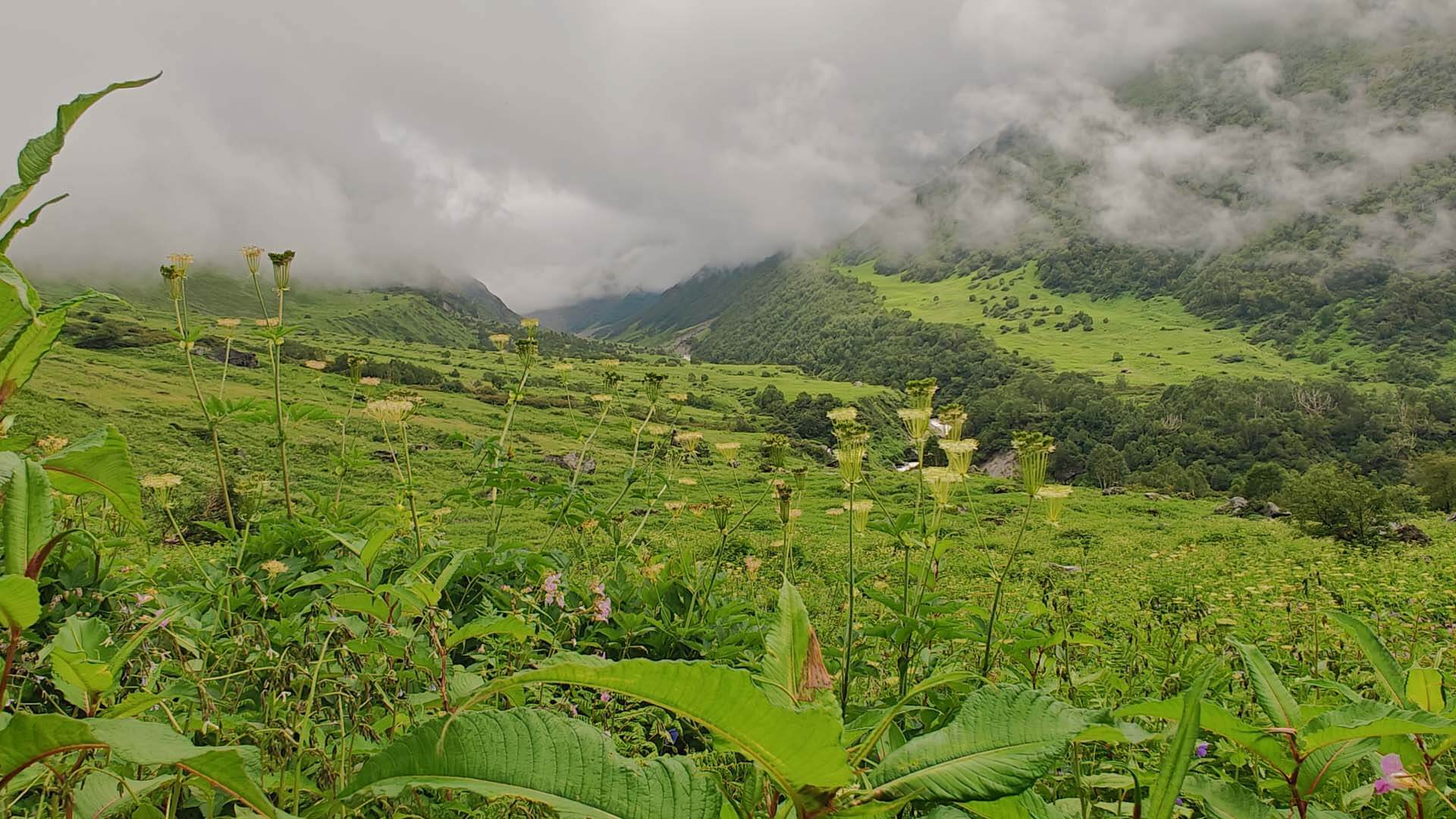
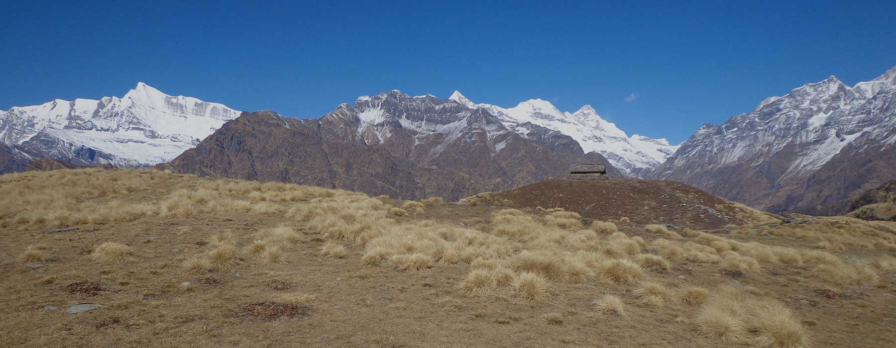
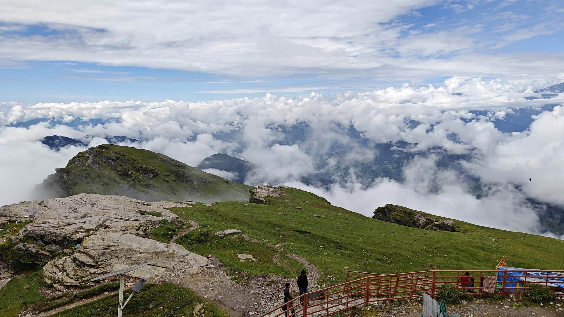
After breakfast, we reach Tolpani from Didina. It is situated in dense forests. Here, huts are there for cows and buffaloes for the village people. It’s a beautiful place.Moving upwards, we reach Ali Bugyal which is a beautiful field of soft grass. We reach Bedni Bugyal via Ali Bugyal. We get to see a long range of Garhwal Himalaya from Ali Bugyal. Trishul, Nandaghugti peak seem to be very near from here. Bedni Kund is in Bedni Bugyal only. Long Staf has said about Bedni Bugyal that this Bugyal of Garhwal is the most beautiful one in Asia. Bedni Kund has a huge religious value because it’s an important destination of Uttarakhand’s Aradhya Goddess Nanda Rajjat Yatra. As per the religious belief, Vedas were created here and that is why it got the name Vedini. With the passage of time, people started calling it Bedni. In Bedni Kund, the shadow of Himalaya looks so beautiful that it releases all the tiredness of the body. Near the Kund is a temple of Shiv-Parvati and an old temple of Mahishasur Mandini is also there. It is considered sacred to take a bath in Bedni Kund. Yagopavit Sanskar are also being done in Bedni Kund. Bedni Bugyal is a very beautiful and mesmerizing Bugyal. It is at a height of 3354 m and at a distance of 12 km.
After breakfast we leave for Patar Nachauni. It is a belief that Goddess Nandadevi had cursed the dancers who came with King Yashodhawal into stones. In ancient’s times, dancers were also called as Patar and that is why this place got the name Patar Nachauni. It is situated at a distance of 6 km from Bedni, at a height of 3650m. Mostly there are strong winds in this place and it gets very cold.
After breakfast at Patar Nachauni, we leave for Bhagubasa. After the 3 km ascent from Patar Nachauni to Kailuwavinayak is situated a temple of Lord Vidyanharta Ganpati Bappa where Bappa relieves the pain n tiredness of all the visitors. The all side view from here is very beautiful. The distance for Bhagubasa from here is 3 km and it takes 4-5 hours to reach here from Patar Nachauni. There is an interesting story behind how Bhagubasa got its name. People say that once Lord Shankar was going to Kailash Mount with Goddess Parvati along with his devotees. Being tired, the devotees used to stop from place to place taking permission from both of them. The tiger stopped at Bhagubasa and the Naag stopped at Chhidhinaag. And this way, it got its name. It is at a height of 4100 m. Bramhakamal, Fankamal and Nilkamal are chiefly found in Bhagubasa.
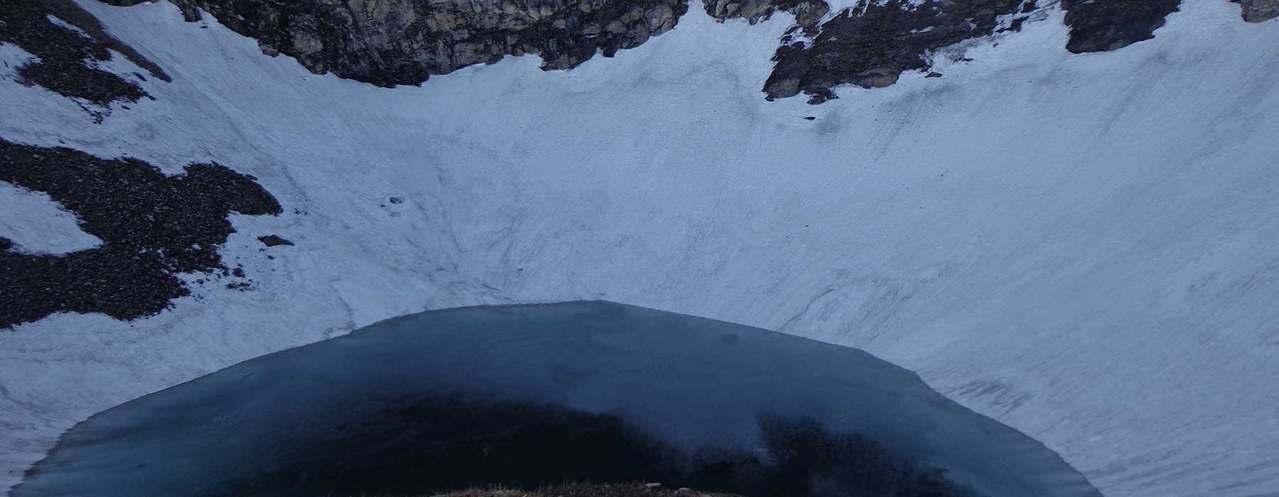
Having breakfast in Bhagubasa, we go for Roopkund Darshan. For Roopkund it is said that once Goddess Parvati and Bholenath were going through the sky way. Goddess Parvati felt thirsty. Then Bholenath seeing white snow everywhere fixed his Trident on the land and a pool was formed. When Goddess Parvati saw her beautiful, mesmerizing face in this pool, Bholenath gave it the name of Roopkund. River Roopganga originates from here and the skeletons found here are believed to be the skeletons of King Jasodhawal of Kannoj and his army. People say that in the times of Rajjat, because of a snow-storm, all these people were buried here alive. There is always a white sheet of snow around Roopkund. Roopkund is at a distance of 5 km from Bhugbasa and it takes 3 hours to reach Bhugbasa from there. The journey from Bhugbasa to Roopkund is a difficult one. After the sight of Roopkund from Bhugbasa, we come back to Bedni Bugyal which takes 4-5 hours.
Having breakfast in Bedni Bugyal, we reach Gairoli Patal. It’s a destination of Goddess Nanda Rajjat Yatra. It’s a beautiful place in dense forests. And this route is full of beautiful Banj, Buransh, Ringal and Deodar forests. We find Nil Ganga on our way. It is said that Lord Shiv and Goddess Nanda had taken bath here. After Nil Ganga comes Rakki Dhar. As per the old beliefs, Goddess Nanda had killed Mahishasur over here. After Rakki Dhar comes Vaan village where there is a temple of famous Ladu Devta and huge Deodar trees are also there. People say that without the sight of Ladu Devta, the Nanda Rajjat Yatra remains incomplete. The temple of Ladu Devta in Vaan is situated in between in between huge Deodar trees. From Vaan we reach Lohajung by Jeep via Karja.
After breakfast, we leave for Kathgodam.
In morning at 6 o’clock, we leave Dehradun by car for Sankri. At first, we get a sight of the Queen of Hills, Mussoorie on our way. As the name Queen of Hills suggests the meaning, matchless beauty. Situated in between the other mountains, this hill station is famous worldwide for its beauty and the beautifully falling Kempty Fall gives peace to our mind. After that we reach Damta around 10 o’clock where we have our breakfast. There is a small market over here. After the breakfast in Damta, we passing through Purola Market which is also a small market, we reach Sankri via Netwar. On the way, we get the sight of Tones River, Rupin River, Supin River. It takes 7-8 hours to reach Sankri from Dehradun. This village is inside the Govind Wild Life Sanctuary and it is the checkpost of the Forest.
After breakfast, we reach Taluka from Sankri by Jeep. This road, on both the sides is full of forests of Deodar, Banj and Pine trees. The whole road of 12 km is very beautiful. Taluka is a small village that has 5-6 shops. This is a beautiful place and Taluka is tha last road head for vehicles. Here, we move forward by the Shore of Supin River and in the shade of Deodar forests. We reach Sima passing through Ditmir village. The whole way is very beautiful. On way, we find many small rivers, streams, etc. that makes our journey more entertaining. Sima is situated on the right hand side of Supin river while going but village Osla is situated on the left hand side of the river while going and it is situated at a height of 100-200 m. Population of this beautiful village is about 250 families. The way towards the right hand side of Sima goes to the Ruinsara Lake. Sima is about 14 km from Taluka that takes about 5-6 hours.
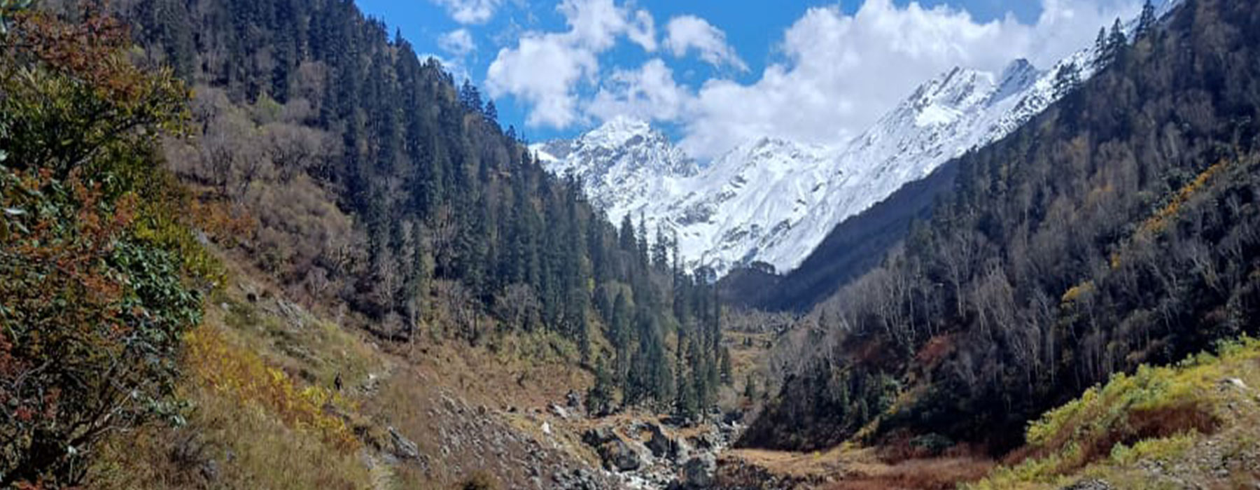
Today after having breakfast, we leave for Har Ki Doon around 8:30 AM. On way, we get a sight of the beautiful temple of Goddess Kaindari Maitri. It is about 2 km away from the village. 4 km from the village starts the farming fields of Osla village which is known as Halse Jhani. From here, we see Kala Nag Mount, Swargarohini Mount, Bandarpoonch Mount. After Halse Jhani comes Kalkatte Dhar which takes a 50 m ascent and from here we see Chaukhamba peak. Then only, Bali pass and Dhundar Kathi pass is also visible. Moving forward we see a beautiful fall and some small rivers, streams etc. Covered with forests of Deodar, this trekking route is very beautiful and it’s a memorable trek. It takes 7-8 hours to reach Har Ki Doon from Sima. Har Ki Doon is an open and very beautiful valley.
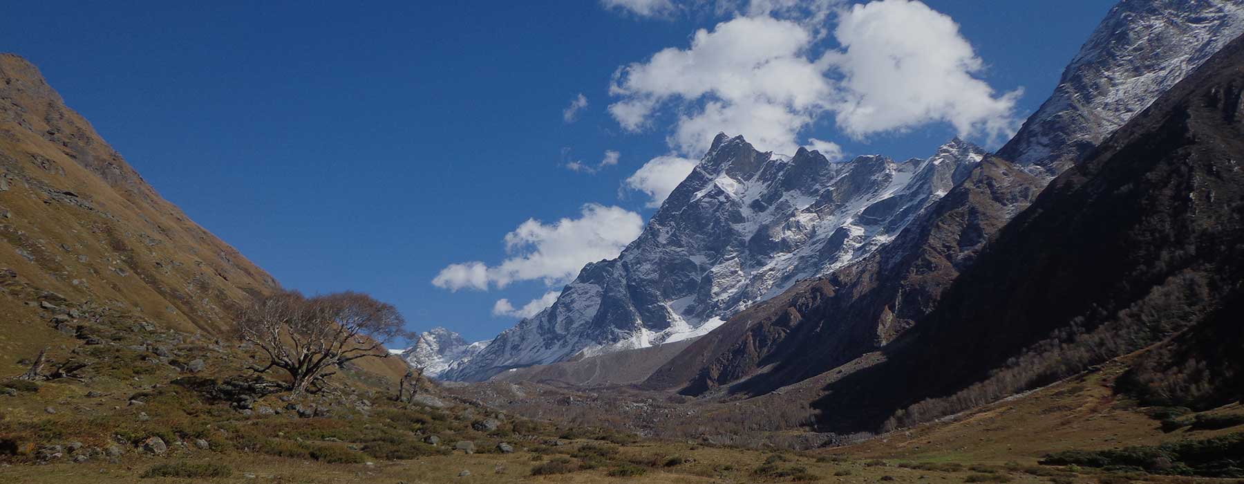
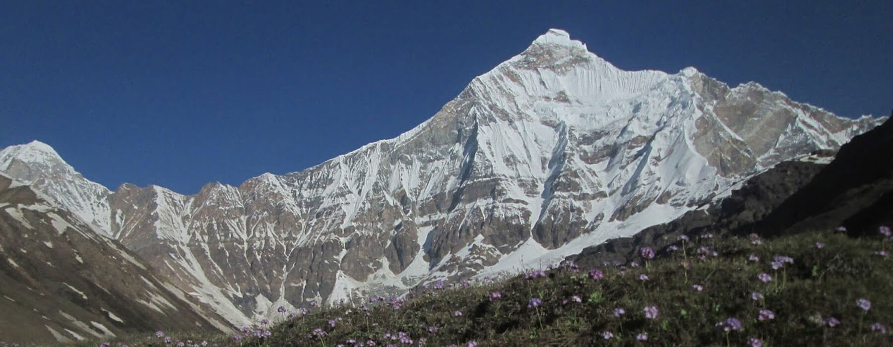
Today after breakfast, we leave Har Ki Doon for Jaundhar Glacier around 7 in the morning. It is situated at a distance of about 12 km from Har Ki Doon. Moving downwards from Har Ki Doon and by the sides of Jaundhar Gad, moving upwards, we walk towards the glacier. After about 6 km we get the View Point of the glacier. Those who do not wish to move further, come back to the base camp after the sight of the glacier and the others come back after reaching the 0 Point. It takes 8 hours to reach the 0 Point of Glacier and packed lunch has to be taken along. Jaundhar glacier is very beautiful and Swargarohini peak is attached to it. While going to Jaundhar glacier from the Base camp, we see about a 2 km long forest of Bhojpatra. As we get back from there, we take evening tea, snacks and rest over there.
After the breakfast, we leave Har Ki Doon for Makinda Lake around 7:30 AM. It is situated at a distance of about 4 km from Har Ki Doon. There is route for Badaun Pass also via Makinda Lake. While going to Makinda Lake, we find trees of Buransh flower in huge number. It takes about 4 hours in coming and going. For lunch we reach Har Ki Doon Base Camp and although Makinda Lake is small but it’s beautiful.
After breakfast we leave for Taluka in Sima. It takes about 5-6 hours by Jeep. After doing lunch in Taluka, we reach Sankri by Jeep. And spend night in a hotel in Sankri.
We leave Sankri for Dehradun at 6 in the morning.
We will go to Bharadi – Song – Munar – Mufi – Pattiyar from Bageshwar by car. From there, we walk for 7 km towards village Jhuni. Village Jhuni is situated at the bottom of Himalayas where about 100 families reside. From village Jhuni, the beautiful sights of Khaljhuni- Mikhila- Khalpatta- Sufi- Lahur etc. are visible. On the way to Jhuni, there are dense forests of Banj-Buransh and river Saryu flows at the bottom.
Today, after an early morning breakfast, we leave Jhuni for Pakuwa Bugyal. It’s a part of a 5 km ascent. After that we have to walk upwards to the mountain range which is also about 5 km. It takes 5-6 hours to reach Pakuwa from Jhuni. As we reach Pakuwa, we get a sight of Himalayas and the peaks of Himalayas mesmerizes us. From here you get to see Pindari glacier, Kafni glacier, Sunderdunga glacier, Mrigbhuni Mountain Range, Baljuri, Panwalidwar Panchachuli, Khaliya top Munsiyari, Nandakot, Maktoli, Trishul, Nanda Bhanar, Bhanoti, Lachpathura, Lamchir, Jhanguj, Creamroll, Nandaghat and other mountain ranges and the ground with soft grass welcomes you swinging with the air.
Today after waking up early at 4 o’clock, from the top of Pakuwa Bugyal, we capture the view of all the sides of the beautiful Himalayas in our camera as well as in our eyes forever. After 1-2 hours, we do our breakfast and after that we leave Pakuwa for Vinayak. This trek is very beautiful. Here, you can find the bird Monal in huge number and the forests of Buransh, Banj, Bhojpatra, Kharsu welcomes you. As you reach Vinayak Top, you’ll find the local village people’s temple of Bhumi Devta-Goddess Bhagwati. It takes us 4-5 hours on this 8 km trek. This route goes along with the Himalayas which is very beautiful and it becomes a memorable trek. Night stay is done in tent in Vinayak.
Today, after the breakfast, we head towards village Sufi from Vinayak. It takes 4-5 hours on this 8 km trek which is a beautiful way and the village Sufi is also very beautiful and it’s a beautiful part of your journey. Night stay is done in Sufi village.
After breakfast we leave Sufi by Jeep towards Kathgodam via Munar-Mog-Bharadi-Bageshwar.
In morning we leave for Munsiyari either by bus or by jeep. On way, we get a beautiful sight of Bhimtal Lake. We reach Almora via Bhimtal, Bhowali and Kainchidham. Going on Pithoragarh road from Almora,we can visit Chitayi Golu Mandir. In Chitayi Golu’s Darbar, devotees write their wishes in letters and hang it and Lord Golu fulfills all their wishes. After that, on our way, we find a small, beautiful and famous hill station called Chaukori. We reach Birthi fall from Chaukori via Thal market. Birthi Fall, falls from a height of about 80 ft and it’s a very beautiful fall. After Birthi, we reach Munsiyari. When we reach Munsiyari, we see Panchachuli mountain range right in front of our eyes that pleases the mind of the tourists and takes away all the tiredness from the tourists. Before we reach Munsiyari, at Kalamuni we see a temple of Goddess Kali and near the Balati Band, Forest Department’s Herbal Garden & beautiful trees of Buransh, Banj, Kharsu, and Deodar pleases the heart. Night stay is done in hotel.
After breakfast, we will go to Dhapa Band by Jeep and from there we walk towards village Lilam. There, after doing our entry registered in the ITBP checkpost, we reach Pankchu. It takes 5-6 hours to go to Pankchu from Dhapa which is at a 12 km distance.
After having breakfast in Pankchu and taking along the packed lunch, we leave for Bogudiyar. About 3 km direct ascent from Pankchu is Nain Singh Top. The name of Nain Singh Top was taken from the famous surveyor of village Milam, P. Nain Singh. P. Nain Singh had done the survey work of George Everest and the other famous peaks. We get down from Nain Singh Top where passing Babaldhar and crossing the bridge near the train, along with the shore of Gauri Ganga, we reach Bogudiyar. The whole way is full of forests of Banj, Kharsu, deodar, Ringal, etc. It takes about 8-9 hours to reach Bogudiyar from Pankchu which is about 18 km. It is on a height of 8910 ft. Night stay is in tent and Bogudiyar is situated near the shore of Gauri Ganga.
After breakfast, we leave Bogudiyar for Rilkot. It is about 15 km from Bogudiyar. Because of calamity, this route has been broken and become long. On way, one can find Flora and Fauna in huge amount. 4-5 km from Bogudiyar, you fill find the temple of Nahardevi. Earlier there was a very beautiful temple but in the floods of year 2013, this temple and the way was drown away. From Nahardevi to the Chhira of Dirkani, you will have to walk very carefully. From Dirkani Chhira, the valley starts to open slowly and gradually and by the time we reach Rilkot, the valley starts to look bigger and the wide banks of Gauri Ganga look very beautiful. It takes 7-8 hours to be there. Rilkot is at a height of 10560 ft. It takes 7-8 hours to reach village Milam from Rilkot.
After breakfast we walk on the road towards village Martoli and after visiting Goddess Nandadevi, we reach village Burphu. From here, after crossing the bridge built over Gauri Ganga, we head towards village Milam. There’s another village on the way called village Bilju. This village by the road side is very beautiful. After walking for about 18 km comes village Milam which is very beautiful and is spread over to long distance. Village Martoli is very beautiful. If you didn’t see village Martoli on Milam trek, you did not see anything. The valley from Burphu to Ganghar is very beautiful and is a spread over. The covered hills give us the feeling as if we are in Switzerland. It is very cold in village Milam during nights. Village Milam is situated at a height of 3420 m. We see Hardeval & Trishui peak on the way and Nandadevi Main and East Peak is also seen. Near the village Burphu, we leave towards village Ganghar for Nandadevi base. On our way, we find village Mapa which is a very beautiful village and from here, village Ganghar is situated at a distance of 4 km. After we reach Ganghar village, we set our camp by the side of the village. Panchu Gaad originates near the village Ganghar. Near Panchu Gaad is the village Panchu. Both are very beautiful and in front of them flows Gauri Ganga. As we reach Ganghar village, we see Nandadevi Pean and Nandadevi East which is a very beautiful sight.
Today after breakfast, we go to Panchu Glacier View Point and after seeing Nandadevi Base Camp, we come back to Ganghar which becomes a memorable moment and seeing so much natural beauty our heart gets self-inspired.
After breakfast, we leave village Ganghar and head towards Rilkot that takes 5-6 hours and it’s a normal trek.
After doing breakfast in Rilkot, we leave for Bogudiyar. It’s a good feeling and the trek is normal.
After an early morning breakfast in Bogudiyar, we take the route for Pankchu. Today’s trek is arduous but the preparations to come back have to be done carefully. It takes 6-7 hours to reach Bogudiyar, Nain Singh Top, Pankchu. The night stay is done in Pankchu.
After an early morning breakfast, we reach Dhapa Band from Pankchu via village Lilam and Jimmy Ghat. From here, we reach our hotel in Munsiyari by Jeep and take the lunch. In evening, after taking bath, we go for Munsiyari’s local sight-seeing.
After breakfast, we leave Munsiyari for Kathgodam.
In morning we leave for Munsiyari either by bus or by jeep. On way, we get a beautiful sight of Bhimtal Lake. We reach Almora via Bhimtal, Bhowali and Kainchidham. Going on Pithoragarh road from Almora,we can visit Chitayi Golu Mandir. In Chitayi Golu’s Darbar, devotees write their wishes in letters and hang it and Lord Golu fulfills all their wishes. After that, on our way, we find a small, beautiful and famous hill station called Chaukori. We reach Birthi fall from Chaukori via Thal market. Birthi Fall, falls from a height of about 80 ft and it’s a very beautiful fall. After Birthi, we reach Munsiyari. When we reach Munsiyari, we see Panchachuli mountain range right in front of our eyes that pleases the mind of the tourists and takes away all the tiredness from the tourists. Before we reach Munsiyari, at Kalamuni we see a temple of Goddess Kali and near the Balati Band, Forest Department’s Herbal Garden & beautiful trees of Buransh, Banj, Kharsu, and Deodar pleases the heart. Night stay is done in hotel.
After breakfast, we will go to Dhapa Band by Jeep and from there we walk towards village Lilam. There, after doing our entry registered in the ITBP checkpost, we reach Pankchu. It takes 5-6 hours to go to Pankchu from Dhapa which is at a 12 km distance.
After having breakfast in Pankchu and taking along the packed lunch, we leave for Bogudiyar. About 3 km direct ascent from Pankchu is Nain Singh Top. The name of Nain Singh Top was taken from the famous surveyor of village Milam, P. Nain Singh. P. Nain Singh had done the survey work of George Everest and the other famous peaks. We get down from Nain Singh Top where passing Babaldhar and crossing the bridge near the train, along with the shore of Gauri Ganga, we reach Bogudiyar. The whole way is full of forests of Banj, Kharsu, deodar, Ringal, etc. It takes about 8-9 hours to reach Bogudiyar from Pankchu which is about 18 km. It is on a height of 8910 ft. Night stay is in tent and Bogudiyar is situated near the shore of Gauri Ganga.
After breakfast, we leave Bogudiyar for Rilkot. It is about 15 km from Bogudiyar. Because of calamity, this route has been broken and become long. On way, one can find Flora and Fauna in huge amount. 4-5 km from Bogudiyar, you fill find the temple of Nahardevi. Earlier there was a very beautiful temple but in the floods of year 2013, this temple and the way was drown away. From Nahardevi to the Chhira of Dirkani, you will have to walk very carefully. From Dirkani Chhira, the valley starts to open slowly and gradually and by the time we reach Rilkot, the valley starts to look bigger and the wide banks of Gauri Ganga look very beautiful. It takes 7-8 hours to be there. Rilkot is at a height of 10560 ft. It takes 7-8 hours to reach village Milam from Rilkot.
After breakfast we walk on the road towards village Martoli and after visiting Goddess Nandadevi, we reach village Burphu. From here, after crossing the bridge built over Gauri Ganga, we head towards village Milam. There’s another village on the way called village Bilju. This village by the road side is very beautiful. After walking for about 18 km comes village Milam which is very beautiful and is spread over to long distance. Village Martoli is very beautiful. If you didn’t see village Martoli on Milam trek, you did not see anything. The valley from Burphu to Ganghar is very beautiful and is a spread over. The covered hills give us the feeling as if we are in Switzerland. It is very cold in village Milam during nights. Village Milam is situated at a height of 3420 m. We see Hardeval & Trishui peak on the way and Nandadevi Main and East is also seen.
After breakfast we go towards Milam Glacier View Point. It is on a distance of 5 km. After seeing the Glacier, we come back to the Base Camp village Milam for lunch. In Evening, we take the knowledge of the village’s civilization. It’s a very simple and easy way.
After breakfast, we leave for Rilkot from village Milam. It takes 5-6 hours to reach Rilkot and it’s a normal track.
After breakfast in Rilkot, we head towards Bogudiyar. It’s a good feeling and the track is normal.
After an early morning breakfast in Bogudiyar, we leave for Pankchu. Today’s trek is arduous but the preparations to come back have to be done carefully. It takes 6-7 hours to reach Bogudiyar, Nain Singh Top, Pankchu. The night stay is done in Pankchu.
After an early morning breakfast, we reach Dhapa Band from Pankchu via village Lilam and Jimmy Ghat. From here, we reach our hotel in Munsiyari by Jeep and take the lunch. In evening, after taking bath, we go for Munsiyari’s local sight-seeing.
After breakfast, we leave Munsiyari for Kathgodam.
We will take bus from Kathgodam for Bageshwar. We will get to see some small hill stations like Bhimtal, Bhowali, Kainchi Dham, Almora, etc. on our way. From Almora, there are two routes for Bageshwar; one via Kosi Kausani Baijnath and the other one through Kasar Devi Binsar Takula. Bageshwar, where sacred confluence of Saryu-Gomti and Tapasthali of Rishi Markandeya is there, an ancient temple of Lord Shankar popular with the name Bagnath temple is situated near the confluence.
Here, Lord Shankar and Goddess Parvati had disguised themselves as tiger and cow in order to wake up Rishi Markandeya from his meditation. Bageshwar is a historical, ancient city having Lord Shankar’s temple on a hill called Nileshwar and Goddess Chandika’s ancient temple on Bhileshwar hill, having river Saryu flowing in between both the temples. You get everything needed for trekking, eatables & clothes in Bageshwar and there are full arrangements for night stays.
After breakfast in morning, we will reach Bharadi via Shore of Saryu River by Jeep. It is the last big market on Pindari trekking route. We will go for the sight of Tapt Kund from Bharadi via Shore of Saryu River and reach Song-Loharkhet and from there we will tramp to Khalidhar. In Khalidhar we will reach Jhandidhar. In Jhandidhar there is a small and beautiful temple of Goddess Nandadevi and there is a small teashop also. . In Jhandidhar, almost all the trampers take rest. From Jhandidhar we reach Talla Dhakuri where there are huts and houses for local people’s animals and from where you’ll get a very beautiful sight. We reach Goddess Chilta temple Dhakuri top from Talla Dhakuri. From here, Pindari valley looks beautiful and the villages of Pindari valley- Badiyakot, Soraag, Kilpara, Dhur, Dola, Teekh, Unniya, Vachham, Jaitoli and the last village of Pindari route- Khati is seen. One route from Dhakuri top goes to Chilta Mudir & Chilta Bugyal and the other one goes directly down to the Dhakuri field. Dhakuri is the point of most beautiful sights of Pindari, Kafni and Sundardhunga route. . From Dhakuri you get to see Mactoli peak, Mrigdhuni peak, Mrigdhuni range, Nandaghat, Nandakot, Nandadevi East, Creamroll, Dharkot, Bhanoti tent peak, Jhanguj, Lajpadhura, Lamchir, Balchuri, etc. mountain ranges. This place will please you and your heart. From Loharkhet to Dhakuri, a route of 9 km will take you around 6 hours. It’s a zigzag way of a slight ascent. You will get water at many places and the whole trekking route is full of forests of Baanj, Buransh, Kharsu, Timur, etc. which is immensely beautiful.
After breakfast in morning, we will leave for village Khati.This whole way goes through forests of Kharsu and Buransh trees. Going 3 km downwards from Dhakuri is a place called Kharkiya where road is there that meets Loharkhet. After Kharkiya is situated a village called Umla that has a primary school for village kids. After Umla village is a place called Dau where 20 families reside and then comes Khati village which is the last village in Pindari trekking. The main source of earning of people of this village is through horses, mules, cows, goats and tourism and the major crops for farming are potato, millet, kidney beans, chawlai, etc. There is a huge temple of goddess Kali in the village and all the tourists move further after visiting the temple. From village Khati is a route for Village Jaitoli which is the last village for Sunderdhunga trekking route. Khati is an 8 km descent from Dhakuri and around a hundred families live there.
DFrom village Khati we reach Ridang. On way, crossing the Sunderdunga river and a slight ascent and zigzag way through the dense forests, we reach the village Jaitoli. It is the last village of Sunderdunga Glacier having potato, kidney beans and chawlai as its major crops, residing 50 families and having a primary school for the village kids.
We leave Jaitoli for Dhungiyadhung. It is a camp place in between a forest which is 8 km away from Jaitoli. It has forests of Ringal, Buransh, Kharsu, Deodar, etc.
After doing breakfast at Dhungiyadhung, we leave for Kathliya. There is a slight ascent on the way. We see forests of Ringal and trees of Buransh flowers. As soon as we reach Kathliya, we get the sight of Maiktoli peak. This whole trekking way is very adventurous and beautiful. Night is spent in tents.
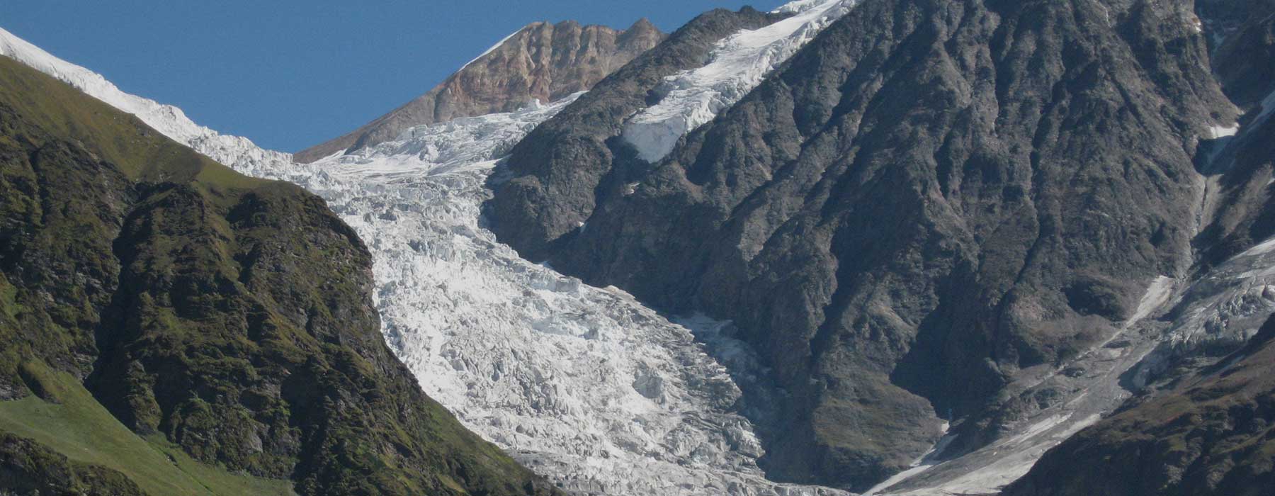
After breakfast in morning, we leave to see the Sunderdunga Glacier. On way in the Sunderdunga River, there is a huge river that works as a bridge. Sunderdunga glacier is named after it as dunga means a stone. We have to go through Bugyals to reach Sunderdunga glacier. On the left to Sunderdunga glacier is Khadkhadiya top. And right above it is Maiktoli Base Camp from where river also originates. We have to go there with packed lunch and it takes 6-7 hours to come and go.
Today in morning, after taking breakfast we reach Devikund from Kathliya via Bailoni Top. Its Goddess Nandadevi’s sacred pool and the belief is that mother goddess baths in this pool. From Bailoni top we get the sight of Tent peak, Bhanoti peak, Panwalidhwar, Maiktoli, Dharkot and other mountain ranges. It takes around 7 hours to go and come back to Kathliya from Bailoni top –Devikund. It is about a 14 km trek.
After doing breakfast in Kathliya, we leave for Jaitoli which takes about 7-8 hours.
After the breakfast, we will take the route for Khati from Jaitoli which is about 7 km away. And then for Dhakuri from Khati which is about 8 km. It takes 4-5 hours to reach Dhakuri from Jaitoli.
After having our meal in Dhakuri, and an ascent of 11 km, there is 9 km trek of descent for Song.And after that we come to Bageshwar by a vehicle.
We will take bus from Kathgodam for Bageshwar. We will get to see some small hill stations like Bhimtal, Bhowali, Kainchi Dham, Almora, etc. on our way. From Almora, there are two routes for Bageshwar; one via Kosi Kausani Baijnath and the other one through Kasar Devi Binsar Takula. Bageshwar, where sacred confluence of Saryu-Gomti and Tapasthali of Rishi Markandeya is there, an ancient temple of Lord Shankar popular with the name Bagnath temple is situated near the confluence.
Here, Lord Shankar and Goddess Parvati had disguised themselves as tiger and cow in order to wake up Rishi Markandeya from his meditation. Bageshwar is a historical, ancient city having Lord Shankar’s temple on a hill called Nileshwar and Goddess Chandika’s ancient temple on Bhileshwar hill, having river Saryu flowing in between both the temples. You get everything needed for trekking, eatables & clothes in Bageshwar and there are full arrangements for night stays.
DAfter breakfast in morning, we will reach Bharadi via Shore of Saryu River by Jeep. It is the last big market on Pindari trekking route. We will go for the sight of Tapt Kund from Bharadi via Shore of Saryu River and reach Song-Loharkhet and from there we will tramp to Khalidhar. In Khalidhar we will reach Jhandidhar. In Jhandidhar there is a small and beautiful temple of Goddess Nandadevi and there is a small teashop also. In Jhandidhar, almost all the trampers take rest. From Jhandidhar we reach Talla Dhakuri where there are huts and houses for local people’s animals and from where you’ll get a very beautiful sight. We reach Goddess Chilta temple Dhakuri top from Talla Dhakuri. From here, Pindari valley looks beautiful and the villages of Pindari valley- Badiyakot, Soraag, Kilpara, Dhur, Dola, Teekh, Unniya, Vachham, Jaitoli and the last village of Pindari route- Khati is seen. One route from Dhakuri top goes to Chilta Mudir & Chilta Bugyal and the other one goes directly down to the Dhakuri field. Dhakuri is the point of most beautiful sights of Pindari, Kafni and Sundardhunga route. From Dhakuri you get to see Maiktoli peak, Mrigdhuni peak, Mrigdhuni range, Nandaghat, Nandakot, Nandadevi East, Creamroll, Dharkot, Bhanoti tent peak, Jhanguj, Lajpadhura, Lamchir, Balchuri, etc. mountain ranges. This place will please you and your heart. From Loharkhet to Dhakuri, a route of 9 km will take you around 6 hours. It’s a zigzag way of a slight ascent. You will get water at many places and the whole trekking route is full of forests of Baanj, Buransh, Kharsu, Timur, etc. which is immensely beautiful.
After breakfast in morning, we will leave for village Khati.This whole way goes through forests of Kharsu and Buransh trees. Going 3 km downwards from Dhakuri is a place called Kharkiya where road is there that meets Loharkhet. After Kharkiya is situated a village called Umla that has a primary school for village kids. After Umla village is a place called Dau where 20 families reside and then comes Khati village which is the last village in Pindari trekking. The main source of earning of people of this village is through horses, mules, cows, goats and tourism and the major crops for farming are potato, millet, kidney beans, chawlai, etc. There is a huge temple of goddess Kali in the village and all the tourists move further after visiting the temple. From village Khati is a route for Village Jaitoli which is the last village for Sunderdhunga trekking route. Khati is an 8 km descent from Dhakuri and around a hundred families live there.
DIn morning, after the breakfast, we will leave from village Khati towards Dhwali and this route from the Shore of Pindar River goes towards Dhwali. In the whole way are the dense forests of Buransh, Kharsu, Baanj and Ringal and there are many beautiful falls as well. This whole route has been damaged quite many times as a result of calamities. This trek of only 12 km is very beautiful and you get a lot of flora and fauna during it. Tourists rest in tent rest houses. From Dhwali, we get a sight of Nandadevi East Mountain.
After breakfast in morning, we leave Dhwali for Phurkiya which is a 7 km way having many small rivers and streams. After walking for 4 km, we take a short rest in Jwar Pani before moving further. It takes almost 4 hours to reach here. This is also a zigzag way of a slight ascent having forests of Kharsu, Buransh, Deodar, etc. By the lunch time, we reach Furkia that has the last rest house for the Pindari trekking.
After doing breakfast at 6 in the morning, we leave to see the 0 Point Pindari Glacier which is about 7 km from here. The route is normal and after walking for 3 hours we reach 0 Point. 5 km from Phurkiya is situated Babaji’s shack and Goddess Nandadevi’s extremely beautiful temple. After Phurkiya, the Pindari Valley starts appearing slowly and gradually. In Pindari valley, you can see the Baljuri, Jhanguj, Panwalidhar, Nandaghat and other peaks right in front and an alluring sight pleases the eyes and the mind. We find Buransh trees in a huge number on this way where sheep and goats come for fodder. From 0 Point, we see the Pindari glacier and head back to Phurkiya for lunch where we stay for the night.
In morning after the breakfast and taking along the packed lunch, we reach Khati from Phurkiya via Dhwali. It takes us around 7 hours to be there.
After breakfast in village Khati, we leave for Dhakuri. On way, there is station for vehicles in Kharkiya where you have to book it a day before if you wish to go to Bageshwar by vehicle as there are only 3-4 vehicles on this route. It takes about 5 hours to reach Dhakuri from Khati which is an 8 km trek.
After doing breakfast at Dhakuri, we take an 11 km ascent and 9 km descent trek of Song. Then we come to Bageshwar by a vehicle.
We pride ourselves on our a friendly approach and professional service when helping you book your perfect trip. We are experts at providing tailor made holidays, taking into account all of your requirements and preferences, we will tailor-make your holiday, acting as a concierge service to take care of everything while you sit back and relax.
Contact Us